A drone survey can look perfect on screen and still be wrong on the ground. That gap between a clean model and a dependable dataset is often where ground control points explained becomes a practical question rather than a technical one. If you are producing mapping, orthomosaics, point clouds or measured outputs for construction, infrastructure or asset management, GCP strategy directly affects whether the result is visually acceptable or commercially usable.
What are ground control points?
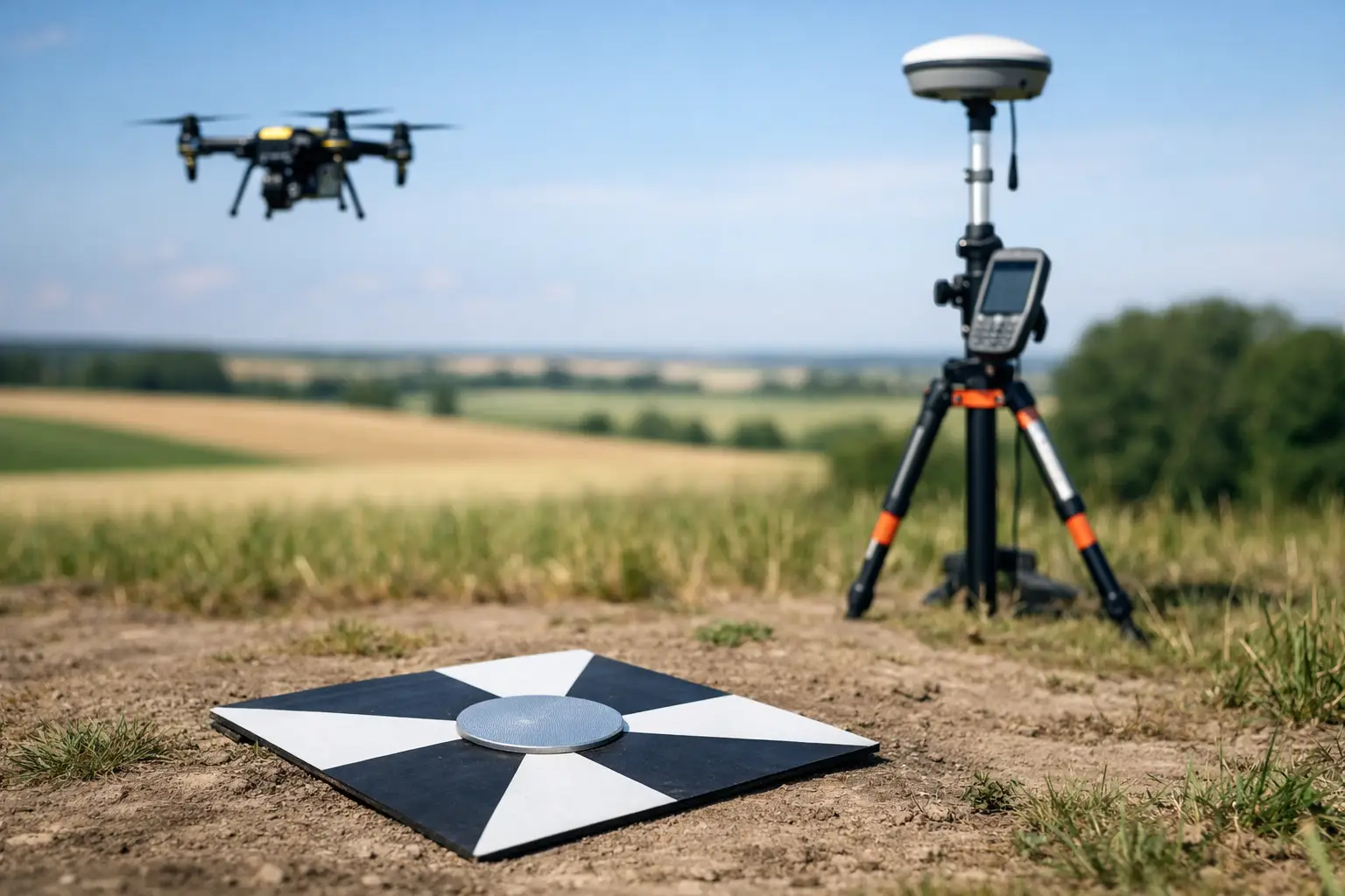
Ground control points, usually shortened to GCPs, are clearly identifiable points on the ground whose coordinates have been measured accurately with survey-grade GNSS, total station or a combination of both. They are used to tie aerial or terrestrial data to a known coordinate system so the final dataset is positioned correctly and scaled properly.
In simple terms, a GCP gives your drone or photogrammetry software a known real-world reference. Instead of relying only on the aircraft’s onboard GNSS, the processing software matches visible markers in the imagery to surveyed coordinates. That reduces positional drift and improves absolute accuracy across the site.
This matters because onboard positioning, even with RTK or PPK, does not solve every error source. Camera calibration, flight height, terrain variation, image overlap, site geometry and weak satellite conditions can all affect results. GCPs help control those variables.
Ground control points explained in real project terms
For professional users, the value of GCPs is not academic. It shows up in whether a volume calculation is defensible, whether a design overlay lands in the right place, and whether repeat surveys align from one visit to the next.
On a construction site, inaccurate ground control can shift an orthomosaic enough to create problems in setting-out checks or progress measurement. On a highway or rail corridor, poor control distribution can introduce distortion along the length of the model. For utilities, forestry and asset inspection, inconsistent control can limit the usefulness of outputs when they are brought into CAD, GIS or asset management systems.
That is why ground control points explained properly should always include a key distinction: GCPs improve the geospatial reliability of the entire workflow, not just the appearance of the deliverable.
How GCPs are used in drone mapping and photogrammetry
In a standard drone survey workflow, visible markers are placed around and through the site before flying. These markers are then surveyed with accurate coordinates. During processing, the software identifies the markers in multiple images and uses those known positions to constrain the model.
The result is usually stronger absolute accuracy and better overall stability. This is especially useful on larger areas, complex terrain, sites with limited distinct features, or projects where outputs will be compared against existing survey control.
It is worth separating three related roles. Some points are used as control, meaning they guide the model adjustment. Others are used as checkpoints, meaning they are held back from processing and used only to verify the finished accuracy. That distinction is critical if you want an honest measure of performance rather than a result that only looks accurate because every point was used to force the solution.
When ground control points are necessary
Not every project needs the same level of control. If the task is a fast visual inspection or a general site overview, onboard GNSS may be enough. If the deliverable will inform design, payment, compliance, engineering decisions or repeatable monitoring, stronger control is usually justified.
The need becomes more obvious on sites with long linear extents, significant elevation change, weak GNSS conditions, repetitive textures or high accuracy requirements. Urban corridors, cuttings, wooded margins, steep stockpiles and infrastructure assets often fall into this category.
RTK and PPK drone systems have improved field efficiency significantly, but they do not make GCPs irrelevant. In many cases they reduce the number of GCPs required rather than removing the need entirely. A well-configured RTK workflow with a sensible number of checkpoints may be sufficient on some projects. On others, a full control network remains the safer option.
It depends on required tolerance, site conditions and the downstream use of the data. That decision should be made before fieldwork starts, not after processing exposes a problem.
Placement matters as much as quantity
A common mistake is assuming that more GCPs automatically means better accuracy. In practice, placement is just as important as count. A small number of well-distributed points will often outperform a larger cluster placed only around the edge of the site.
Control should normally cover the full project area, including corners, edges and internal sections where possible. On sites with height variation, include points across different elevations rather than keeping everything on a single level. Long narrow surveys need control along their length, not just at either end.
Markers also need to be clearly visible in imagery. If the target is too small, poorly contrasted or partially obscured, the software may not identify it consistently. That introduces uncertainty before processing even begins.
For busy operational sites, marker survivability matters too. A perfectly surveyed target is of little use if a machine moves it before the flight or site traffic covers it in mud.
How accuracy is really checked
The best way to assess survey quality is not to trust the software report at face value, but to review independent checkpoints and compare them against project tolerances. Horizontal and vertical errors should both be examined, because some datasets appear acceptable in plan while underperforming in elevation.
This is particularly relevant for volume work, drainage assessment and earthworks monitoring, where small vertical errors can have a substantial operational impact. If your workflow only checks visual fit, you may miss the very issue that affects the commercial decision.
A dependable process includes surveyed control, independent validation and clear reporting. For professional buyers, accuracy claims should always be tied to method and site conditions, not presented as a universal figure.
Ground control points explained for LiDAR workflows
Although GCPs are most often discussed in photogrammetry, they also matter in LiDAR projects. UAV LiDAR and mobile mapping systems can achieve excellent relative accuracy, but absolute positioning still depends on good GNSS, IMU performance and sound control procedures.
In LiDAR workflows, control points and check points are commonly used to validate strip alignment, confirm georeferencing quality and support confidence in deliverables such as terrain models, asset coordinates and measured clearances. If the data will support engineering, planning or condition assessment, independent verification remains good practice.
The exact role of control varies by sensor, platform and mission profile. A high-grade LiDAR system with strong trajectory processing may require fewer physical controls than a purely photogrammetric survey, but validation is still essential where accuracy is contract-critical.
Common problems when GCPs are handled poorly
Most GCP issues are avoidable. The usual failures are weak distribution, imprecise surveying, inconsistent target identification, or mixing coordinate systems without proper checks. Even experienced teams can lose accuracy if field and processing stages are not joined up.
Another issue is using all measured points as control and none as checkpoints. That may improve the adjustment statistics, but it gives little evidence of real-world accuracy. It is better to prove the dataset than to overfit it.
There is also a commercial trade-off. More control means more time on site. Less control means faster deployment, but potentially higher risk. The right balance depends on the specification, not just the desire to reduce field hours.
Choosing the right approach for your project
For many organisations, the question is not whether GCPs exist, but how much control is enough for the intended output. If you are surveying a small open site with an RTK-enabled enterprise drone, a limited control strategy with independent checkpoints may be efficient and fully adequate. If you are mapping a complex construction corridor for engineering decisions, more extensive control is likely to be justified.
That is where an integrated geospatial approach makes a difference. Hardware capability, correction services, survey control, processing method and final data requirements all need to align. Treating GCPs as a separate box-ticking exercise usually leads to either overspend or underperformance.
For clients planning drone, GNSS or LiDAR deployment, LiDAR Tech UK typically advises on control strategy in the context of the whole workflow rather than as an isolated survey task. That is generally the most reliable route to consistent, decision-ready outputs.
Ground control is not glamorous, but it is often the difference between a dataset that looks convincing and one that stands up when accuracy really matters. If your outputs will feed into design, measurement or asset decisions, it is worth asking the harder question at the start: not simply whether you used GCPs, but whether you used them well.