When a tunnel survey has to be completed during a tight possession window, every minute matters. LiDAR tunnel mapping services give asset owners, contractors and survey teams a faster way to capture accurate 3D geometry in confined, low-light and operationally sensitive environments where traditional methods can quickly become slow, disruptive and costly.
Where LiDAR tunnel mapping services add value
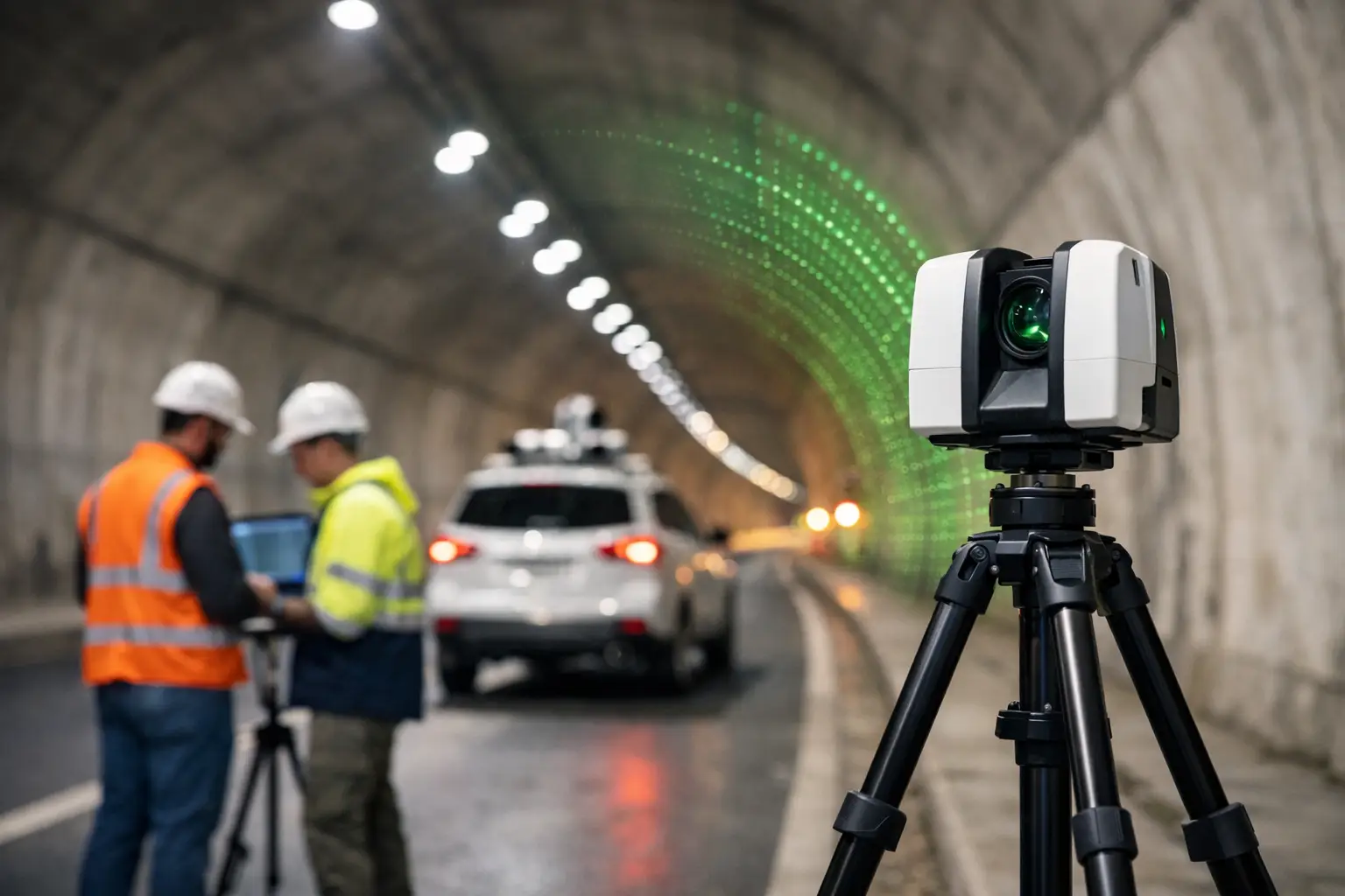
Tunnels are difficult survey environments by default. GNSS is unavailable, visibility can be poor, access may be restricted, and safe working time is often limited by operations. At the same time, the need for dependable data is high. Rail tunnels, highway bores, utility corridors, culverts, mines and service passages all require precise measurement for inspection, clearance analysis, maintenance planning and design validation.
LiDAR tunnel mapping services are well suited to these conditions because they capture dense point cloud data rapidly across long linear assets. Instead of relying on discrete measured points, project teams receive a full 3D record of the tunnel lining, track bed, cable routes, drainage runs, service penetrations and other internal features. That level of detail supports better decision-making when assessing deformation, planning remedial works or coordinating future installations.
For many organisations, the commercial advantage is just as important as the technical one. Shorter field time can reduce possession costs, lessen operational disruption and improve site safety by limiting the duration surveyors spend in hazardous or access-controlled areas.
What a tunnel LiDAR survey actually delivers
A well-executed tunnel survey is not simply about collecting data quickly. The output has to be usable for engineering, design and asset management. That is where specification, control strategy and processing discipline matter.
Most projects require a registered and georeferenced point cloud, but deliverables can vary depending on the asset and downstream use. A client may need measured cross sections at fixed intervals, clearance envelopes, deformation analysis, digital terrain and track models, 2D drawings, BIM-ready geometry or a textured 3D model for visual review. In some cases, the priority is condition assessment. In others, it is dimensional control for refurbishment, extension or clash detection.
This is why tunnel mapping should not be treated as a one-size-fits-all scanning exercise. Scanner selection, traverse design, control establishment and data processing all need to align with the required accuracy and final output format.
Why tunnels need a different survey approach
The challenge with tunnels is that the environment works against standard survey workflows. Satellite positioning drops out, repetitive surfaces can complicate registration, and dust, moisture or reflective materials may affect data quality. Curved alignments, service recesses and variable lighting can also create blind spots if the capture plan is not thought through properly.
A practical tunnel LiDAR methodology usually combines mobile or handheld scanning with static control where needed. For long corridors, mobile capture can cover ground efficiently. For areas that demand tighter tolerances, such as portal interfaces, plant rooms, structural defects or complex junctions, static scanning and total station control may still be the right choice.
That balance matters. Mobile methods are faster, but speed alone is not the goal. If a refurbishment contractor needs millimetre-level confidence for prefabricated components, the survey design has to reflect that. If the objective is condition mapping across a long asset, a different capture strategy may be more cost-effective.
Accuracy, speed and the trade-off between them
Professional buyers tend to ask the same question first: how accurate is the data? The honest answer is that it depends on the tunnel, the control available and the purpose of the survey.
LiDAR tunnel mapping services can achieve highly accurate results, but accuracy should always be defined against project tolerances rather than broad marketing claims. Relative accuracy within a local section may be excellent, while absolute accuracy across a long alignment depends heavily on control, registration and verification. In a tunnel with limited access points and long distances between control stations, maintaining confidence over the full corridor requires careful planning.
There is also a trade-off between productivity and precision. Rapid mobile scanning can transform field efficiency, especially in rail and utilities environments, but not every job needs the same specification. A project for general asset documentation may prioritise speed and coverage. A project for structural remediation or clearance analysis may justify a slower workflow with denser control and additional validation.
The right service provider should be clear about that distinction from the outset. Over-specifying a survey increases cost unnecessarily. Under-specifying it creates risk later, usually when design teams start relying on the data.
Typical use cases across UK infrastructure
In the UK market, tunnel scanning is increasingly used across transport, utilities and civil engineering projects where downtime is expensive and access is difficult. Rail operators and contractors use LiDAR for gauging, lining assessment, drainage review, cable route documentation and pre-work planning. Highway teams use it to document road tunnels, service bays, ventilation areas and structural elements prior to maintenance or upgrade works.
Utility and infrastructure managers also benefit from 3D tunnel data when recording pipework, conduits, cable trays and associated access points. Where legacy drawings are incomplete or unreliable, a current measured dataset can significantly reduce uncertainty before intrusive works begin.
Heritage and conservation projects are another strong fit. Historic tunnels and underground structures often have irregular geometry that is difficult to capture with traditional methods alone. LiDAR provides a detailed digital record that supports restoration, monitoring and long-term documentation.
What to look for in a service provider
Choosing between lidar tunnel mapping services is not just about who owns a scanner. It is about who can plan the survey properly, work safely in restricted environments and deliver data in a format your team can use immediately.
Start with methodology. A credible provider should explain how they will establish control, manage registration, verify accuracy and deal with known tunnel constraints such as poor lighting, repetitive surfaces and access limitations. They should also be clear on whether the project is best handled with static scanning, mobile mapping or a hybrid approach.
Experience in operational environments matters as well. Tunnel work often involves possession planning, safety protocols, coordination with principal contractors and compliance with site-specific requirements. That is not the same as scanning an empty building or open site.
Then look closely at deliverables. Some providers stop at a raw or lightly processed point cloud. Others can supply CAD linework, sections, meshed models, asset extraction and analysis-ready datasets. If your engineering team needs a particular format, confirm that before the fieldwork begins.
For many clients, support after capture is just as valuable as the survey itself. LiDAR Tech UK, for example, works across hardware, software and project delivery, which is useful when clients need a practical route from data capture through to usable outputs rather than a standalone scanning exercise.
Planning a successful tunnel survey
Good tunnel mapping starts before anyone steps on site. Scope definition is critical. The survey brief should identify the length of tunnel, access constraints, required outputs, accuracy tolerances, control available and any problem areas that need special attention.
A site-specific risk assessment is equally important. Confined spaces, live infrastructure, uneven surfaces, water ingress and limited escape routes all affect how the survey is carried out. In many cases, the safest survey is the one completed in the shortest realistic time, provided quality is not compromised.
Processing should also be factored into the programme from the start. Large tunnel point clouds can be data-heavy, and registration, cleaning, classification and modelling all take time. If a contractor needs fast design input for a live programme, the delivery schedule has to reflect that urgency.
Why the cheapest option often costs more later
Tunnel surveys sit early in the project chain, but the impact of poor data usually appears later. Misaligned point clouds, weak control or incomplete coverage can lead to design rework, site clashes, delayed approvals and repeat visits. In restricted tunnel environments, a return survey can be expensive and difficult to arrange.
That is why value should be measured against project risk, not just day rates. Accurate, well-processed LiDAR data can reduce uncertainty across design, coordination and construction stages. It can also provide a defensible record of asset condition at a specific point in time, which is useful for compliance, handover and dispute avoidance.
For buyers comparing providers, the best question is not simply how quickly the tunnel can be scanned. It is whether the resulting dataset will stand up to engineering use, commercial pressure and operational scrutiny.
If you are planning works in a tunnel environment, the strongest starting point is a survey scope that matches the real decisions your team needs to make. Get that right, and the data becomes more than a visual record – it becomes a dependable basis for safer access, clearer design and better project control.