When a site programme is tight and the deliverable has to stand up to scrutiny, the RTK vs PPK mapping decision is not academic. It affects how quickly you can mobilise, how much field control you need, and how much confidence you have in the final coordinates. For surveyors, drone operators and engineering teams, the right choice usually comes down to project risk, correction availability and the way your team actually works on site.
RTK vs PPK mapping in simple terms
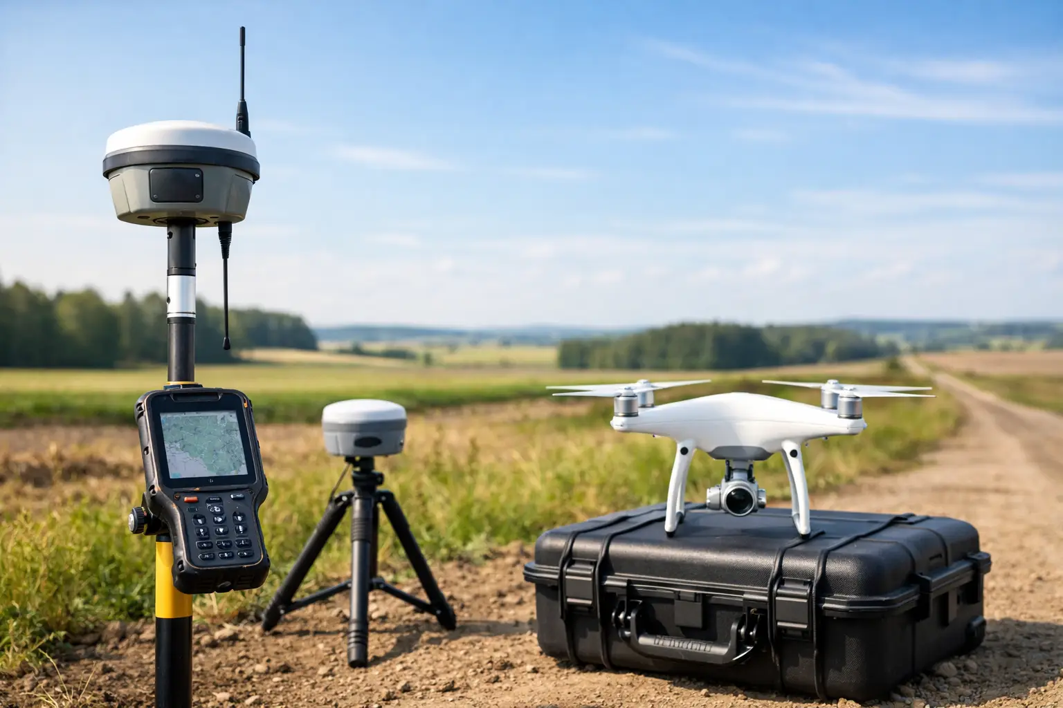
RTK, or Real-Time Kinematic, applies correction data during the survey or flight. The rover or drone receives live corrections from a base station or network service, then fixes positions in real time. That gives you immediate feedback and allows data capture with survey-grade positioning while the work is being carried out.
PPK, or Post-Processed Kinematic, records raw GNSS observations during the job and applies corrections later in the office. Instead of relying on a continuous live link during capture, you process the trajectory afterwards against base data or reference observations. The practical result is similar in ambition – high-accuracy positioning – but the workflow, risk profile and site requirements are different.
For professional mapping, that difference matters. One method prioritises real-time certainty in the field. The other gives you more flexibility when communications are unreliable or the environment is difficult.
Why the choice matters on real projects
On a straightforward stockpile survey in an area with good mobile coverage, RTK may be the quickest option. You can fly, confirm solution status on site and move straight into processing. If the objective is speed with minimal rework, that is hard to ignore.
On a linear infrastructure corridor, forestry site or remote utility route, the picture changes. Signal interruptions, uneven canopy, terrain masking and poor network access can all affect a live correction stream. In those cases, PPK often gives teams more resilience because the survey does not depend on maintaining a constant correction link throughout the operation.
That is why there is no universal winner in RTK vs PPK mapping. Accuracy alone does not settle it. You also need to consider field conditions, operational pressure and what happens if something fails halfway through the job.
Accuracy expectations: RTK vs PPK mapping
Both methods can support centimetre-level results when deployed correctly. In practice, final accuracy depends on GNSS visibility, baseline length, quality of control, sensor calibration, flight planning and processing discipline. The positioning method is only one part of the chain.
RTK can perform extremely well when the correction source is stable and the fix quality is maintained throughout the mission. If your drone or rover holds a reliable fixed solution and your control checks agree, the output can be very efficient and highly dependable.
PPK can be equally strong, and in some scenarios more forgiving. Because you process afterwards, you can inspect the data quality in detail, reject poor epochs and work with a fuller view of what happened during the mission. That can be useful where live correction interruptions would otherwise create uncertainty.
The important point for commercial buyers is this: neither RTK nor PPK removes the need for sensible survey control and validation. If the job carries contractual, engineering or legal weight, independent checks remain essential.
Where RTK has the advantage
RTK suits teams that need immediate positional confidence during capture. On active construction sites, quarries, development land and routine topographical work, that can reduce wasted time. You know in the field whether you have a fixed solution, whether the system is behaving as expected and whether a re-flight is needed before demobilisation.
It also simplifies some workflows. If your equipment integrates well with a correction service and your team follows consistent setup procedures, RTK can reduce the burden of office-based trajectory processing. For busy operators managing repeat surveys across multiple sites, that efficiency has clear value.
RTK also works well when your client expects a fast turnaround and the site environment is controlled enough to support it. If mobile data coverage is stable or a local base can be established easily, real-time correction is often the cleanest route.
Where PPK has the advantage
PPK comes into its own when field conditions are less predictable. Remote sites, poor mobile coverage, partial sky obstruction and long corridors all make live corrections harder to trust. With PPK, the mission can proceed without depending on a continuous correction feed.
That can reduce operational stress. Instead of constantly monitoring whether the link has dropped out, the team focuses on consistent capture, sound base data and proper post-processing. For organisations surveying infrastructure, forestry, utilities and rural assets, that flexibility can be a decisive benefit.
PPK is also attractive where data auditability matters. Because the trajectory is processed afterwards, there is often more opportunity to review and document what happened. For some clients and quality systems, that additional traceability is valuable.
Ground control points still matter
A common mistake in discussions about RTK vs PPK mapping is treating both as a complete replacement for ground control. In reality, reduced control does not mean zero control.
RTK-enabled and PPK-enabled workflows can cut the number of ground control points needed for mapping, especially with well-calibrated sensors and disciplined procedures. That saves time on hazardous or difficult sites. But check points are still vital for validating horizontal and vertical accuracy.
If the terrain is complex, the site is large, or the output will feed into design, volume calculations or compliance documentation, independent checks are not optional. Good practice is not just about claiming a specification. It is about proving that the delivered data meets it.
Workflow, risk and team capability
The better question is often not which method is more accurate, but which method introduces less risk for your operation.
RTK shifts confidence to the field stage. If the corrections are sound and the fix remains stable, you leave site with a strong idea of data quality. The trade-off is dependency on communications and setup discipline. A weak network, poor base placement or unnoticed fix issue can undermine the result quickly.
PPK shifts more responsibility to the office stage. You gain flexibility during capture, but you need a team that can manage raw data properly, process trajectories correctly and maintain a documented workflow. If that capability is missing, the advantage of PPK can be lost in rework or inconsistent outputs.
This is where equipment choice and supplier support matter. Integrated GNSS, drones, correction services and processing software reduce friction, but only if the workflow is properly understood. For many organisations, a dependable support partner matters as much as the specification sheet.
Which method suits which project?
For construction progress mapping, routine earthworks, site stockpiles and many standard topographical drone surveys, RTK is often the practical first choice. It is fast, efficient and well suited to teams working to tight operational windows.
For remote land surveys, utility corridors, forestry mapping and sites where coverage is unreliable, PPK often provides more resilience. It lets teams capture data without hinging success on a live correction feed.
For higher-stakes projects, many professionals use a blended mindset rather than a rigid preference. They choose hardware that supports both approaches, apply proper check points and decide on the day based on signal conditions, site access and project tolerances. That is usually the most commercially sensible position.
Making the right decision
If your priority is speed in the field, straightforward workflows and immediate quality visibility, RTK is usually the stronger fit. If your priority is flexibility, resilience in difficult environments and reduced dependence on live connectivity, PPK may be the better option.
For UK organisations investing in drone mapping or GNSS survey capability, the best decision comes from matching the method to the project environment, the required deliverable and your internal capacity to process and verify results. LiDAR Tech UK typically sees the strongest outcomes where clients assess the full workflow rather than chasing a headline feature.
The useful test is simple: choose the method that gives you reliable coordinates with the least operational risk, not the one that sounds more advanced on paper.