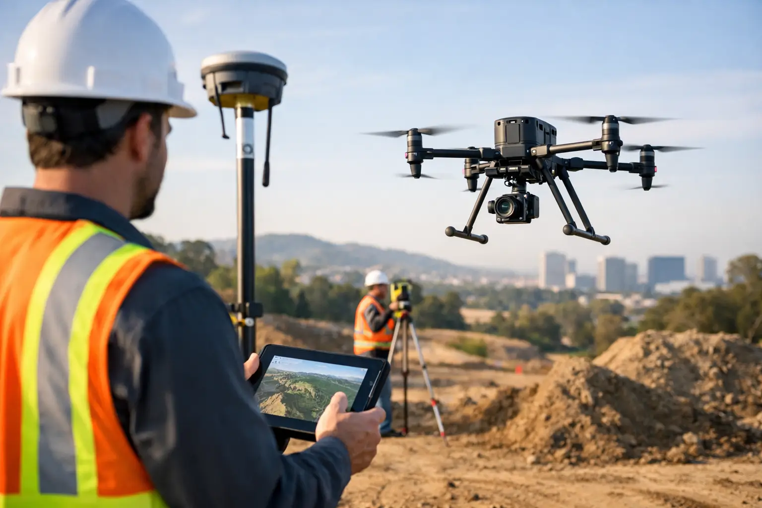
When a site programme slips because survey data arrives late, the problem is rarely just field time. It is usually a workflow issue – too many handoffs, inconsistent data quality, or equipment that cannot keep pace with project demands. Enterprise drone surveying solutions address that gap by combining aircraft, sensors, positioning, software and support into a system that can deliver repeatable results at scale.
For professional buyers, the question is not whether drones can capture data quickly. That point is already well proven. The real decision is whether a drone-based workflow can meet the accuracy, reliability and output standards your organisation needs across multiple sites, teams and use cases. That is where enterprise-grade capability matters.
What enterprise drone surveying solutions actually mean
The term is often used loosely, but in practice enterprise drone surveying solutions are built for operational use rather than occasional flying. They are designed to support repeatable surveying, mapping and inspection tasks with controlled data capture, dependable positioning, compatible software and a support structure behind the hardware.
That distinction matters. A lower-cost drone may produce acceptable imagery for basic visual records, but enterprise operations need more than a useful picture. They need measurable outputs such as georeferenced orthomosaics, point clouds, digital surface models, stockpile volumes, corridor surveys and inspection datasets that can be used in CAD, GIS and asset management workflows.
The solution therefore sits across the full chain. Aircraft performance affects coverage and uptime. Payload choice determines whether you are collecting RGB, thermal or LiDAR data. RTK or PPK capability influences positional accuracy. Processing software governs how quickly raw data becomes usable deliverables. Training and technical support reduce operational risk. If one part is weak, the whole workflow suffers.
Where enterprise drone surveying solutions deliver value
Surveying teams usually adopt drone systems for one of three reasons: speed, access or consistency. On many construction and infrastructure sites, all three apply at once.
For topographic mapping, drones can cover larger areas in less time than traditional ground-only methods, especially where line of sight is poor or terrain is difficult. For inspections, they reduce the need to place personnel near unstable structures, live assets or steep embankments. For progress monitoring, they make it practical to capture the same site repeatedly and compare outputs over time.
Utilities, highways and rail operators often see the strongest value where assets are dispersed and difficult to inspect efficiently from the ground. Forestry and land management users benefit from broad area coverage and, where required, the added penetration and surface detail that LiDAR can provide in vegetated environments. Quarrying and earthworks teams tend to focus on measurement speed, stockpile calculations and regular volumetric reporting.
The commercial benefit is not just faster flying. It is faster decisions. When data arrives in the right format, with the right level of confidence, project teams can update quantities, verify progress, detect issues earlier and reduce revisits.
Choosing the right sensor for the job
Not every survey requirement needs the same payload, and this is where many purchasing decisions go wrong. The aircraft is important, but the sensor usually defines the value of the outcome.
RGB photogrammetry remains the most widely used option for general mapping and site documentation. It is cost-effective, proven and suitable for many topographic and progress-monitoring tasks, provided lighting, overlap and ground control are managed properly. For construction, aggregates and planning work, it is often the most practical starting point.
LiDAR becomes more relevant when terrain is obscured by vegetation, when consistent elevation capture is critical, or when clients require dense 3D data with reduced dependence on image texture. It also suits asset and corridor applications where detailed surface geometry matters. The trade-off is cost. LiDAR payloads and processing workflows are typically more expensive, so the business case should be tied to clear operational need rather than perceived prestige.
Thermal sensors serve a different purpose again. They are less about conventional surveying and more about condition assessment, heat loss, solar inspection and fault detection. For many organisations, thermal capability complements mapping work but does not replace it.
Accuracy is a workflow issue, not a brochure claim
Professional buyers know that published accuracy figures only tell part of the story. Enterprise drone surveying solutions can support high-accuracy outputs, but only when the complete workflow is controlled.
RTK and PPK positioning improve confidence in image and LiDAR georeferencing, reducing the need for dense ground control in some scenarios. Even so, site conditions, survey design, flight planning, calibration, base data and processing settings all influence the final result. A strong drone platform cannot compensate for poor mission planning or weak quality assurance.
This is why experienced operators still validate outputs against known control and apply appropriate checks before data is issued. If your work supports engineering design, quantity verification or regulatory reporting, accuracy should be discussed in terms of achievable project outcomes, not headline specifications alone.
For some organisations, that means building an internal QA process. For others, it makes more sense to work with a provider that can supply the hardware, training and project support together. LiDAR Tech UK operates in that space, where equipment capability and field delivery need to align.
Integration matters more than features alone
One of the biggest differences between entry-level and enterprise-grade adoption is integration. A drone may have an impressive sensor and flight time, but if the data cannot move efficiently into your existing workflow, the operational value drops quickly.
Survey and engineering teams need outputs that work with the software they already use. That may mean CAD-compatible surfaces, GIS-ready layers, classified point clouds, mesh models or inspection reports that feed into asset management systems. Commercially, the strongest solutions are the ones that reduce friction between capture and action.
This also applies to fleet management and internal governance. Larger organisations often need standard operating procedures, pilot training records, consistent file structures, maintenance planning and support arrangements that keep systems available across multiple teams. In that environment, buying a drone is easy. Running a dependable surveying operation is harder.
What to assess before you invest
A sensible procurement process starts with application fit rather than brand preference. Ask what you need to measure, how often you need to capture it, what outputs your teams require, and what tolerances are acceptable. That quickly narrows the right sensor, aircraft class and software stack.
You should also assess who will operate the system. If your team already has geospatial expertise, an in-house deployment may be straightforward with the right training and support. If not, a managed service or hybrid model may be more efficient, especially where deadlines are tight or data standards are demanding.
Budget should be viewed over the full operating life, not just the initial purchase. Hardware cost is only one line item. Training, software licensing, batteries, maintenance, correction services, processing time and staff capacity all affect total cost of ownership. Cheaper platforms can become expensive if they create rework or unreliable outputs.
Support is another practical differentiator. When a project depends on timely capture, responsive technical help matters. Authorised supply, implementation guidance and aftersales support are often more valuable than a marginal difference in headline specification.
When to buy equipment and when to outsource
There is no universal answer here. If you have regular survey demand, internal resource and a clear workflow for processing and using the data, ownership can deliver strong long-term value. It gives you scheduling control, repeat capture capability and the opportunity to standardise surveys across your portfolio.
If your requirement is intermittent, highly specialised or tied to short-term project peaks, outsourcing may be the better commercial choice. The same applies where advanced LiDAR processing, complex corridor work or inspection reporting requires expertise that would take time to build internally.
Many organisations now take a mixed approach. They use in-house drones for routine mapping and progress capture, then bring in specialist support for higher-accuracy surveys, LiDAR missions or periods of intense demand. That model often gives the best balance of control and flexibility.
Enterprise drone surveying solutions in the UK market
For UK organisations, operational fit also includes local realities. Weather windows can be narrow. Airspace restrictions vary significantly by region. Site access, public safety and project compliance all need careful management. Equipment and workflows should therefore be selected with UK operating conditions in mind, not just laboratory performance.
That is one reason buyers increasingly look for suppliers that can do more than ship hardware. They want advice on payload selection, training, correction services, deployment planning and data outputs. They also want a partner that understands how surveying, mapping and inspection requirements differ between construction, utilities, land management and public-sector work.
The strongest enterprise drone surveying solutions are not defined by a single aircraft model. They are defined by how reliably they produce usable data, how well they fit the job, and how effectively they can be supported over time.
If you are assessing your next surveying workflow, start with the outcome rather than the platform. The right system is the one that gives your team dependable data, repeatable processes and the confidence to scale without compromising accuracy.