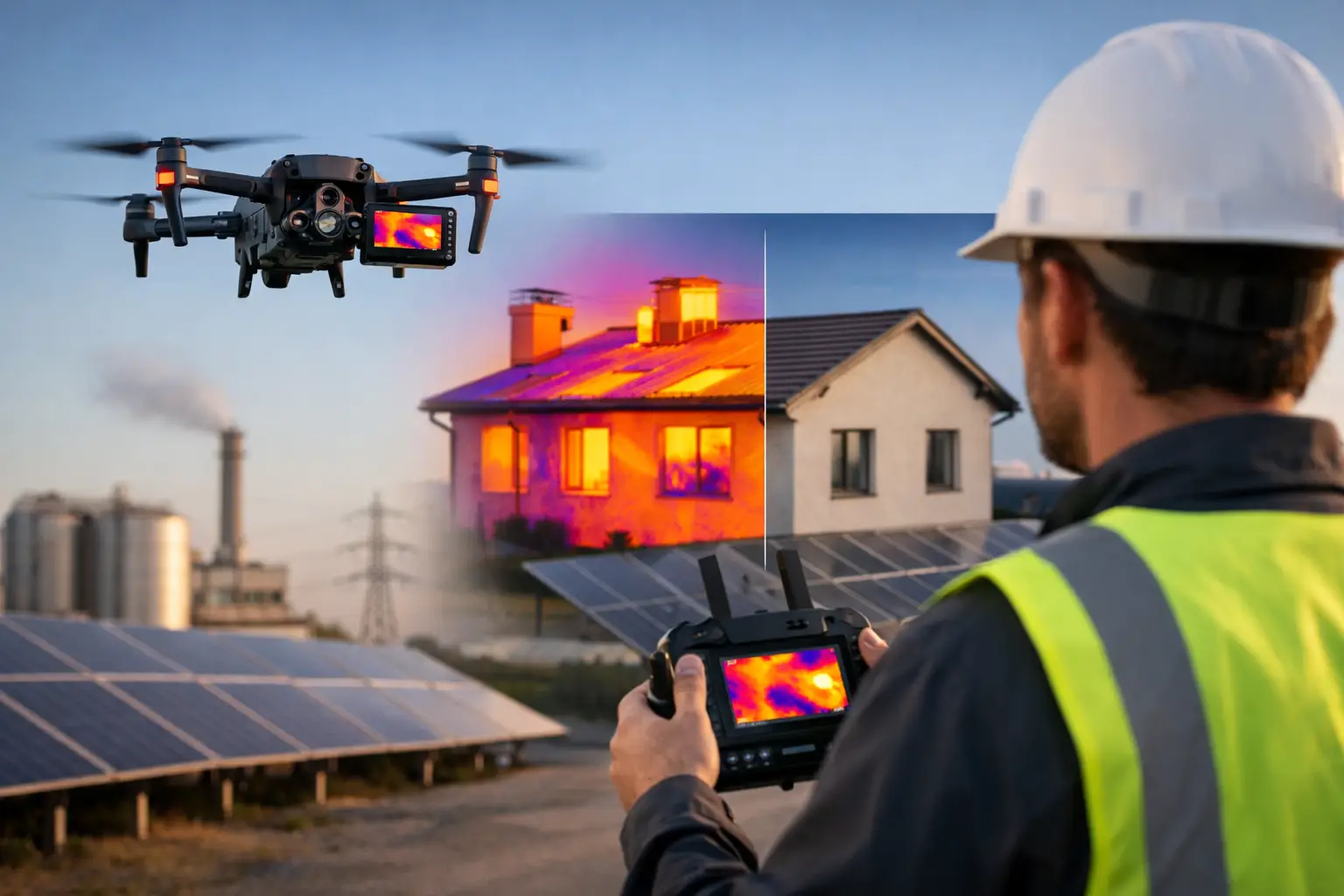
When a roof leak, overheated electrical connection or insulation gap sits out of reach, delay usually costs more than the defect itself. Drone thermal inspection services give asset owners and contractors a faster way to identify heat-related issues across buildings, infrastructure and energy assets without relying on slow access methods or broad assumptions.
For UK organisations managing dispersed sites, ageing infrastructure or safety-critical equipment, the value is practical. Thermal data collected from an enterprise drone can reveal temperature anomalies that are not visible in standard RGB imagery. That matters when the task is not simply to look at an asset, but to understand where heat loss, moisture ingress, electrical faults or mechanical stress may already be developing.
What drone thermal inspection services actually deliver
At a basic level, a thermal inspection drone captures infrared imagery that shows relative temperature differences across a surface or component. In a professional service, that raw capture is only one part of the job. The useful output is the interpretation, geo-referencing, reporting and follow-up evidence that allows maintenance teams, engineers and surveyors to act with confidence.
A competent thermal inspection service should therefore provide more than flights and images. It should include mission planning, safe site operations, calibrated sensor use where required, environmental checks, and deliverables that make sense for the asset type. Depending on the project, that may mean annotated thermal imagery, orthomosaics, defect maps, CAD-compatible datasets, inspection reports or side-by-side RGB and thermal comparisons.
The difference between a consumer-style aerial image set and a commercial inspection service is significant. Professional buyers need repeatability, traceable workflows and outputs that support decisions around repair, compliance, maintenance planning or further investigation.
Where drone thermal inspection services are most effective
Drone thermal inspection services are particularly effective where access is difficult, working at height introduces unnecessary risk, or large surface areas make manual checks inefficient. Roof inspections are a common example. Flat roofs on commercial and public-sector buildings can be surveyed quickly to identify trapped moisture, insulation defects and heat loss patterns, often with less disruption than scaffold-based investigations.
In solar, thermal imaging is used to identify underperforming panels, hot spots and string-level anomalies across utility-scale or commercial arrays. On industrial sites, thermal inspection can support the assessment of process equipment, pipework, tanks and mechanical assets where elevated temperatures may indicate developing faults.
Utilities and infrastructure teams also benefit. Substations, overhead assets, bridges and transport structures often require inspection in places where access windows are short and safety constraints are high. A drone-based approach can reduce time on site while improving visibility of wide or elevated asset areas.
There is, however, an important caveat. Thermal imaging does not diagnose every defect on its own. It highlights temperature differences. The cause still needs to be understood in context, which is why experienced operators and correctly structured reporting matter.
Why thermal inspections are not just standard drone surveys with a different camera
Infrared sensors do not behave like ordinary visual cameras. Readings can be affected by emissivity, reflective surfaces, weather conditions, viewing angle, time of day and the thermal behaviour of the material itself. A metal roof, for example, can produce misleading results if the survey is carried out under poor conditions or interpreted without understanding how that surface responds to sunlight and ambient temperature.
That is why project planning is critical. The best time to inspect a building for heat loss may not be the best time to inspect a solar array for performance anomalies. Wind, recent rainfall, cloud cover and solar loading can all influence results. In some cases, the right answer is to postpone the flight rather than collect compromised data.
For professional clients, this is one of the strongest reasons to use a specialist provider rather than treating thermal capture as an add-on. The hardware matters, but the survey design and interpretation matter just as much.
What to expect from a professional workflow
A reliable provider will usually start by defining the asset, inspection objective and required output. That sounds straightforward, but it shapes everything from flight altitude to sensor settings and report format. If the objective is to locate roof moisture, the workflow will differ from an inspection aimed at electrical fault detection or district heat network assessment.
Pre-site planning should cover airspace restrictions, permissions, access, risk assessment and environmental suitability. On site, the operation needs to be carried out by qualified personnel using enterprise-grade equipment with enough stability, image quality and thermal capability for the task.
After capture, data processing is where the inspection becomes commercially useful. Thermal images may be aligned with visible imagery, stitched into mapped outputs or analysed frame by frame, depending on the application. Clear reporting should distinguish between observed anomalies, likely causes and areas where further ground verification is recommended.
This is also where an integrated geospatial provider adds value. If the same team can support drone operations, mapping, GNSS control, LiDAR capture and data processing, the result is usually a cleaner workflow and better-aligned deliverables for engineering or asset management teams.
Choosing the right provider for drone thermal inspection services
Not every drone operator is an inspection specialist, and not every thermal specialist understands geospatial-grade data requirements. For commercial and public-sector buyers, provider selection should focus on capability rather than headline price alone.
Sensor quality is one part of the decision. So is operational experience in your sector. An inspection of a school roof, a solar farm and a live utility asset may all use thermal imaging, but the planning, risk controls and reporting requirements are very different. Buyers should look for evidence of enterprise drone experience, inspection methodology, understanding of environmental constraints and the ability to deliver actionable outputs rather than generic imagery.
It is also worth asking how findings will be presented. Maintenance teams usually need concise defect identification and location referencing. Surveyors and engineers may require georeferenced datasets and higher integration with existing mapping or CAD workflows. A service is only efficient if the output fits the downstream task.
LiDAR Tech UK operates in exactly this space, supporting organisations that need accurate aerial inspection data, dependable field operations and deliverables that work within wider surveying and asset management processes.
Limits, trade-offs and when another method may be better
Drone thermal inspection is efficient, but it is not universal. Internal defects may not present a measurable external thermal signature. Dense vegetation, poor line of sight or highly reflective materials can reduce result quality. Some assets also need close-contact testing or internal access to confirm the source of a problem.
There are also regulatory and operational limits. Airspace constraints, urban environments, weather and site safety requirements can all affect whether a drone survey is practical on a given date or at all. In those cases, a mixed-method inspection strategy may be the better option.
The key point is that thermal drone data works best as part of a structured inspection process. It can narrow down fault locations quickly, reduce unnecessary access costs and improve maintenance prioritisation, but it should not be treated as a substitute for every other form of engineering assessment.
The commercial case for acting earlier
Most organisations do not lose money because a defect exists. They lose money because it is found late, after performance has dropped, energy costs have risen or access and repair requirements have expanded. Drone thermal inspection services are valuable because they bring earlier visibility to assets that are otherwise checked too slowly or too infrequently.
That is especially relevant for portfolios. Commercial property managers, utilities teams, local authorities and contractors responsible for multiple sites need inspection methods that scale. A drone-based thermal survey can cover more ground in less time, while improving safety and giving decision-makers visual evidence they can share internally.
For buyers comparing service options, the question is not simply whether a drone can collect thermal imagery. The real question is whether the provider can turn that imagery into reliable, site-ready information that supports maintenance, budgeting and risk reduction.
If the cost of access is high, the asset is difficult to inspect, or heat-related faults carry operational consequences, thermal surveying by drone is often the sensible place to start. The strongest results come when the survey is planned around the asset, the environment and the decision that needs to be made next.