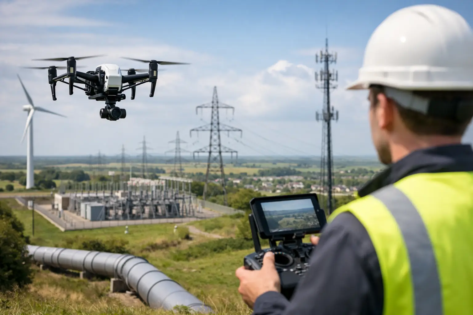
A utility corridor rarely fails in a convenient place. It runs across farmland, along roads, through substations, over water and into areas where traditional survey access is slow, disruptive and expensive. That is exactly why drone mapping for utilities has moved from a useful option to a serious operational tool for network owners, contractors and asset managers who need timely, accurate spatial data.
For utilities, the value is not simply that a drone can fly. The real advantage is that it can capture repeatable geospatial data across large, linear and often difficult environments, then convert that information into outputs that support maintenance, design, inspection and compliance. When deployed properly, drone mapping shortens field time, improves situational awareness and reduces the number of people exposed to live or hazardous environments.
Where drone mapping for utilities delivers value
Utilities operate complex asset networks with constant pressure on uptime, safety and cost control. Electricity distribution, transmission, water, wastewater, gas and telecoms all depend on current site information to make sound decisions. The challenge is that many assets are spread across broad estates or difficult terrain, and legacy records are not always current enough for modern planning.
Drone mapping is particularly effective where teams need an up-to-date view of overhead lines, substations, pipe routes, treatment works, pumping stations, access routes and vegetation encroachment. A well-planned survey can produce orthomosaics, digital surface models, point clouds and 3D reconstructions that give engineering and asset teams a shared visual reference. That matters when multiple contractors, designers and maintenance crews are working from the same base information.
There is also a commercial advantage. Traditional methods still have an important role, especially where statutory control, high-precision set-out or detailed ground verification is required, but they can be labour-intensive for large-area reconnaissance and periodic condition monitoring. Drone-based capture allows utilities to reserve boots-on-the-ground effort for the places that genuinely need it.
Typical utility use cases
The strongest use cases tend to combine access difficulty, safety exposure and the need for measurable outputs. Overhead powerline corridor mapping is one of the clearest examples. Utilities need to understand conductor clearances, nearby structures, terrain change and vegetation growth. Drone survey can collect corridor data quickly and provide a basis for identifying risk areas before they become service issues.
Substations are another good fit, particularly when teams need current topographic context, drainage understanding, stockpile measurement, perimeter condition records or progress monitoring during upgrade works. In water and wastewater environments, drones help map treatment sites, lagoons, reservoirs and remote access routes without delaying operations. For telecoms and gas infrastructure, they can support route planning, condition recording and change detection over dispersed assets.
It depends, however, on the level of detail required. If the brief is broad situational mapping, photogrammetry may be enough. If the site includes dense vegetation, complex vertical assets or a need for deeper terrain penetration, LiDAR often becomes the better choice.
Photogrammetry or LiDAR?
This is where many utility projects are won or lost. The right sensor choice affects data quality, workflow speed and whether the final outputs are actually useful to engineering teams.
Photogrammetry is often the most economical route for generating high-resolution visual mapping. It works well for open sites, corridor overview, condition recording and surface modelling where good image overlap and clear visibility are achievable. For substations, compounds and treatment works with visible surfaces, photogrammetry can deliver excellent detail and intuitive outputs.
LiDAR becomes more valuable when utilities need reliable elevation data in vegetated corridors, more consistent geometry in low-texture environments or detailed 3D capture of infrastructure with complex forms. For transmission routes crossing woodland, embankments or uneven ground, LiDAR can provide a far more dependable terrain model than image-only methods. It is also highly effective where engineering teams need point cloud data for modelling, clearance assessment or digital twin workflows.
The answer is not always either-or. In many utility projects, a combined approach gives the best result. Imagery supplies visual context and inspection value, while LiDAR delivers stronger geometric performance. For professional buyers, the decision should come back to output requirements, operating environment and the cost of getting the data wrong.
Accuracy is only useful if the workflow is controlled
Utilities do not need attractive maps for their own sake. They need defensible data that supports real decisions. That makes positioning, ground control and processing discipline critical.
RTK and PPK workflows improve positional performance, but they are not a substitute for survey control where the specification demands it. Ground control points, check points and clear QA procedures remain essential, particularly for regulated environments, engineering design or any deliverable that will feed into CAD or GIS systems. The same applies to flight planning. Altitude, overlap, speed, sensor angle and corridor alignment all influence the final result.
This is one reason utility buyers often prefer a provider that understands both equipment capability and project delivery. Supplying a drone is one part of the equation. Making sure it produces dependable utility-grade outputs is another. LiDAR Tech UK works in that practical space, supporting organisations with hardware, workflow advice and survey delivery where required.
Safety and operational access
Safety is one of the strongest drivers behind utility drone adoption, but it should not be overstated. A drone does not remove risk. It changes the risk profile.
Used well, it reduces the need for surveyors to work near live assets, steep embankments, unstable ground, water edges or active carriageways. It can limit scaffold requirements and reduce prolonged site occupation. For remote assets, it can also shorten exposure time and lower travel costs.
At the same time, utility environments introduce their own constraints. Electromagnetic interference, restricted airspace, weather exposure, confined operating areas and proximity to live infrastructure all require careful planning. Competent operators, clear method statements and a realistic understanding of environmental limitations are essential. In some situations, the safest decision is to avoid flying altogether and use an alternative capture method.
Data outputs that utility teams can actually use
The best survey is the one that fits into the client’s workflow without creating another bottleneck. Utility teams usually need outputs that can move directly into design, analysis, inspection planning or asset records.
That may mean orthomosaics for corridor review, DSMs and DTMs for drainage and route analysis, georeferenced imagery for condition reporting, or point clouds for 3D modelling and clash assessment. Increasingly, clients also want datasets that support change detection over time, especially on vegetation management, construction progress and erosion-prone areas.
This is where service quality matters as much as sensor quality. If the data arrives late, in the wrong format or without adequate QA, the operational advantage disappears. Professional buyers should assess not just aircraft and payload specifications, but also data-processing standards, coordinate system handling, deliverable formats and the level of technical support behind the project.
What to consider before adopting drone mapping
For utilities looking to build an internal capability or appoint a delivery partner, the key question is operational fit. Start with the assets you need to survey most often and the decisions those surveys need to support. A rapid visual overview, a design-grade terrain model and a vegetation encroachment study may all require different workflows.
Then look at scale and frequency. If you need regular repeat surveys across multiple sites, investing in enterprise drone systems, RTK infrastructure and staff training may make sense. If demand is occasional or the projects are technically demanding, outsourced delivery can be more cost-effective. Many organisations end up with a mixed model, using in-house teams for routine capture and specialist support for higher-complexity sites.
It is also worth considering data governance from the start. Utilities handle sensitive infrastructure information, and that affects how data is captured, processed, stored and shared. Security, auditability and clear project controls should sit alongside flight performance and sensor capability in any buying decision.
Why the market is moving this way
Utilities are under pressure to inspect more assets, document more change and justify more investment, often with limited field resource. Drone mapping answers part of that challenge because it gives teams a faster route from site visit to actionable data. Not every utility job should be flown, and not every project needs LiDAR, but the direction of travel is clear. Organisations that combine the right aircraft, the right sensors and the right geospatial workflow are better placed to plan maintenance, reduce risk and make informed asset decisions.
The most useful next step is usually not to ask which drone is best, but which workflow will produce the data your utility team can trust on Monday morning.