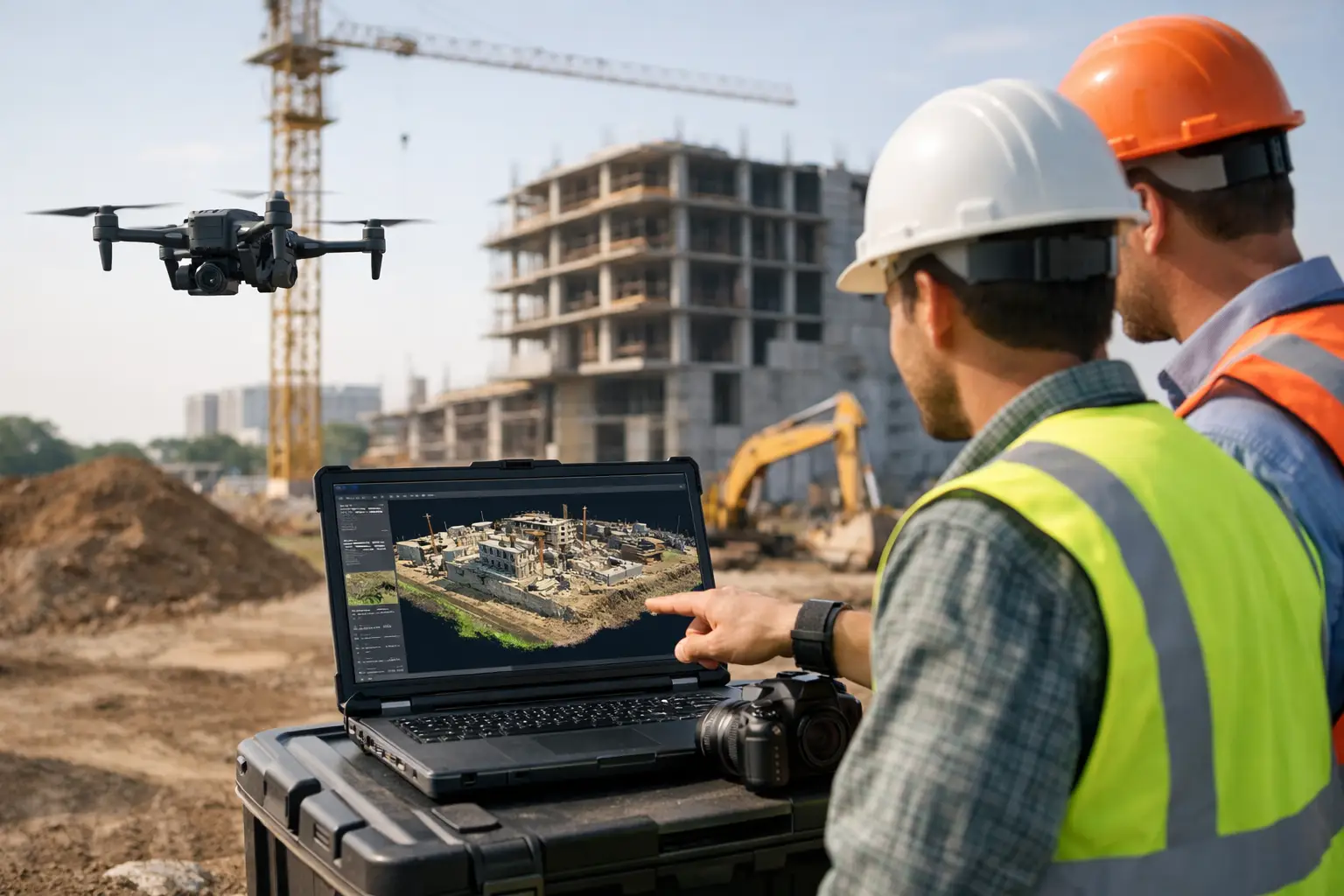
A site manager checking cut and fill against programme, a surveyor validating stockpile volumes, and a commercial team reviewing progress claims all need the same thing – current, reliable site data. That is where photogrammetry for construction sites has become commercially valuable. Done properly, it turns regular image capture into measurable 2D and 3D outputs that support planning, reporting and decision-making without slowing site operations.
For contractors and developers, the appeal is straightforward. You can document large areas quickly, revisit conditions after the fact, and produce visual records that are easier for wider project teams to understand than raw field notes alone. The real benefit, however, is not simply having aerial imagery. It is having imagery processed into georeferenced outputs that can be checked against design, compared over time and used as part of a wider surveying workflow.
Where photogrammetry for construction sites fits best
Photogrammetry is particularly effective where you need broad site coverage, repeatable capture and visual context. Earthworks schemes, housing developments, highways projects, utilities corridors and quarry environments are all strong candidates. On these sites, regular drone or ground-based image capture can produce orthomosaics, surface models, point clouds and volume calculations that support both operational and commercial decisions.
It is often used for topographic overviews, progress monitoring and stakeholder reporting because it gives teams a clear visual model of what is happening on the ground. It also helps when access is limited. Areas near unstable ground, active plant movements or incomplete formations can be documented without sending personnel into unnecessary risk.
That said, photogrammetry is not a replacement for every survey method. If a project requires millimetre-level precision on structural features, façade tolerances or steelwork checks, you may need terrestrial laser scanning, total station observations or a combined workflow. The right question is not whether photogrammetry is better than traditional survey. It is whether it is the right tool for the specific output, accuracy requirement and site condition.
What data outputs matter on a live project
Construction teams rarely need imagery for its own sake. They need usable outputs that fit existing design, engineering and reporting workflows. In practice, that usually means georeferenced orthophotos for planning and communication, digital surface models for terrain review, point clouds for 3D interpretation, and volumetric analysis for materials management.
Orthomosaics are useful because they provide a current, measurable site image that can be shared across delivery teams. A planner can review access routes, a site engineer can inspect temporary works layouts, and a commercial manager can reference progress without relying on outdated marked-up drawings. Surface models and contours become more valuable when grading, haul roads, drainage corridors or spoil placement need to be reviewed against intent.
Volume calculations are one of the most common commercial uses. Stockpile measurement, cut-and-fill monitoring and imported material tracking can all be handled efficiently through repeated capture. The key is consistency in methodology. If capture height, overlap, control and processing standards vary from one survey to the next, comparisons become less reliable.
Accuracy depends on more than the drone
There is a common assumption that a better aircraft automatically guarantees better results. In reality, accuracy in photogrammetry depends on the full workflow: camera quality, flight planning, overlap, control, RTK or PPK correction, ground conditions, lighting, processing settings and operator competence.
Ground control points still matter in many scenarios, particularly where tighter absolute accuracy is required or where site conditions are challenging. RTK-enabled drones can reduce field setup and improve efficiency, but they do not remove the need for verification. On construction projects, confidence in the output is just as important as the output itself. That means checking deliverables against known coordinates, reviewing error reports and understanding where tolerances are acceptable and where they are not.
Surface texture also affects results. Fresh asphalt, standing water, repetitive materials and featureless surfaces can all reduce model quality. Similarly, tall structures, deep excavations and cluttered compounds may create occlusions that are better handled with supplementary ground capture or LiDAR. This is why specification should be led by site conditions and project objectives, not by a one-size-fits-all survey plan.
Why contractors use it for progress and reporting
Construction reporting often suffers from a gap between field activity and office visibility. Photogrammetry helps close that gap because it creates a dated visual and measurable record of the site at a given point in time. For project managers, that supports clearer progress reviews. For directors and clients, it provides a more objective basis for understanding status across large or complex developments.
There is also a practical benefit in dispute avoidance. When site conditions, material quantities or sequence of works are later questioned, having an organised archive of georeferenced captures can be extremely useful. It will not solve every contractual issue, but it can reduce ambiguity around what was present, where it was located and how the site changed over time.
This is especially valuable on multi-phase schemes where several contractors, consultants and client-side stakeholders need access to a common picture. A current orthomosaic or 3D model supports coordination in a way that isolated site photos rarely can.
When photogrammetry is enough, and when LiDAR is better
For many construction environments, photogrammetry offers excellent value because it captures rich visual detail over large areas at relatively low operational cost. If the site has good texture, clear visibility and standard earthworks or progress-monitoring requirements, it is often the most efficient option.
LiDAR becomes more attractive when vegetation, poor lighting, complex vertical geometry or sparse surface texture starts to compromise image-based reconstruction. It can also be the better choice where point density on difficult surfaces is critical or where a project needs stronger performance in mixed environments. On some sites, the best answer is a combined approach – photogrammetry for visual context and broad modelling, with LiDAR or terrestrial scanning used for higher-confidence geometry in critical zones.
That combined model is increasingly common because clients do not want fragmented data capture. They want a workflow that produces dependable deliverables with minimal repeat visits. This is where an experienced geospatial supplier or service partner adds value. The technology matters, but survey design, processing discipline and support capability matter just as much.
Operational considerations before deployment
Before adopting photogrammetry for construction sites, it is worth looking beyond the aircraft and software licence. The practical questions are about throughput, staff competence, compliance and output requirements. Who is going to capture the data? How often will surveys be flown? What level of control is needed? How quickly do teams need processed deliverables back?
There is also the matter of airspace, site safety and operating procedures. Urban and infrastructure projects can bring restrictions that need careful planning. Live construction environments require clear coordination with site management, exclusion zones where appropriate and sensible scheduling around plant activity and deliveries.
Processing capacity should not be overlooked. A contractor may be able to capture imagery quickly, but if the office team cannot process and quality-check datasets promptly, the commercial value drops. Fast data capture only helps when it leads to timely decisions.
For some organisations, building an in-house workflow makes sense, particularly if surveys are frequent and standardised across multiple projects. For others, outsourced delivery or a hybrid model is more efficient. LiDAR Tech UK typically sees the best results where clients match the operating model to project volume, internal expertise and reporting deadlines rather than buying purely on headline specification.
Choosing a commercially sound workflow
The strongest photogrammetry workflows on construction sites are not necessarily the most complex. They are the ones designed around measurable outcomes. If your team needs monthly earthworks volumes, weekly progress orthomosaics and occasional design comparison, specify exactly that. If your client needs CAD-ready surfaces tied to site control, build the workflow around those deliverables from the start.
This avoids a common problem: collecting impressive-looking data that does not answer the project’s actual questions. Professional buyers should be assessing photogrammetry on accuracy, repeatability, output compatibility, turnaround time and support, not on imagery alone.
Used correctly, photogrammetry gives construction teams a faster way to understand the site they are building. The real advantage is not that it produces attractive models. It is that it helps teams measure change, reduce uncertainty and make better decisions while the job is still live.