
Overhead electrical cables create a three-dimensional planning challenge. Before maintenance, access or construction work begins, teams need to understand the relationship between conductors, surrounding structures and the space that people, tools and equipment could occupy. The FJD Trion X1 handheld LiDAR scanner can help create a measurable 3D record to support that assessment.
This railway example illustrates a potential workflow: capture the surrounding environment, review the point cloud in FJD Trion Model and document relevant distances for competent review. It is an illustrative use case, rather than a completed compliance assessment or an endorsed railway survey.

The use case: turn a site visit into evidence for planning
A photograph gives useful context, but a point cloud allows the reviewer to inspect spatial relationships from different viewpoints. Where the relevant conductors and assets have been captured and validated, teams can examine cable positions relative to signals, lighting, platforms, access areas and proposed equipment locations.
For example, a team planning maintenance to a structure near overhead electrical equipment could use the scan to identify potential clearance constraints before developing its method statement. This can help the planner ask better questions of the asset owner and identify where further survey, isolation or a different work method is required.
How this supports statutory risk assessment
In Great Britain, regulation 3 of the Management of Health and Safety at Work Regulations 1999 requires employers to assess work-related risks and review assessments when circumstances warrant. A dated, checked 3D survey can form part of the evidence used to identify hazards and select controls. The legislation does not mandate use of a LiDAR scanner.
The Electricity at Work Regulations 1989 also impose duties relating to prevention of electrical danger and competence. HSE guidance GS6, Avoiding danger from overhead power lines, explains precautions for work near overhead lines. GS6 is guidance, rather than a separate statutory regulation.
There is no single statutory safe distance that can be applied to every overhead cable and every activity. The electrical system, voltage, asset-owner requirements and foreseeable movement of people, equipment and conductors all matter. A measured geometric gap is an input to the assessment; it does not itself establish a safe approach distance.
For railway overhead line equipment, use the infrastructure manager’s applicable electrical safety standards, access arrangements and authorised planning processes. General overhead-line guidance must not be used to authorise railway work. See Network Rail’s electrical safety information. Nothing in this example implies Network Rail approval or endorsement.
A practical survey-to-review workflow
1. Define the task and obtain access authority. Identify the work activity, assets and required survey confidence with the responsible competent person and asset owner. Plan the scanning activity itself under the applicable safe system of work; non-contact scanning still requires safe access and positioning.
2. Capture from authorised positions. Use the X1 to record the surrounding geometry without moving people or equipment into prohibited areas to improve coverage. Treat overhead lines as live unless the owner has confirmed otherwise. Stop if the planned capture cannot be completed safely.
3. Check the point cloud before measuring. Confirm coverage, units, scale, registration and identification of each relevant conductor. Thin wires, reflective surfaces, occlusion and SLAM drift can affect results. A missing or sparse conductor return is missing evidence, not proof of clearance. Arrange an appropriate additional survey where the required confidence cannot be demonstrated.
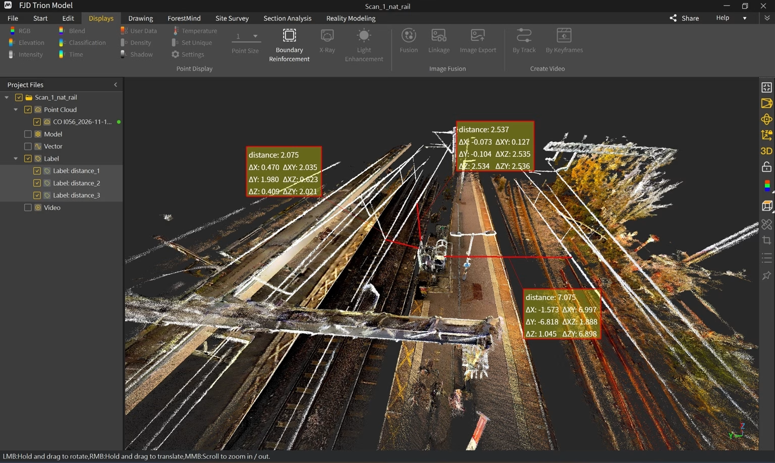
4. Assess the relevant geometry. In FJD Trion Model or suitable survey software, examine sections and point-to-point measurements. Distinguish vertical, horizontal and true 3D distances. A selected pair of points may not represent the shortest conductor-to-object distance. Assess the complete work envelope, including tool reach, lifting equipment, loads and foreseeable movements.
5. Apply the approved limits and document the decision. The responsible competent person should compare validated geometry with the limits and controls specified through the asset owner’s process. Allow for measurement uncertainty, conductor sag and sway, operating conditions and equipment movement. Where margins are insufficient or uncertain, revise the plan or obtain the required electrical protection arrangements before work.
What the measurement screenshot tells us
The supplied screenshot shows three software distance annotations. These demonstrate how selected relationships can be recorded in the model. They do not establish which electrical clearance rule applies, whether the selected endpoints represent the closest approach, or whether a proposed activity is safe. Decimal places on screen do not prove equivalent survey accuracy.
A useful evidence pack would include the survey date and conditions, equipment and processing details, coordinate and unit information, coverage limitations, validation checks, labelled sections, measurement uncertainty, the source and revision of the applicable clearance criteria, and the competent reviewer’s conclusions. Review it when the site, work activity or relevant conditions change.
The value for project teams
The X1 can help teams communicate spatial constraints, review the same 3D evidence away from site and preserve a record of the geometry observed at capture. Potential applications include railway asset maintenance planning, construction logistics and access assessments near overhead infrastructure, subject to suitable survey validation and the relevant owner’s requirements.
A scan supports the risk assessment; it does not certify electrical safety, replace isolation or permits, or authorise access or work. The appropriate survey method and acceptance criteria must be agreed for the task.
Explore the FJD Trion X1
LiDAR Tech UK supplies FJD Trion systems with UK demonstrations, training and support. Explore the FJD Trion X1 and contact us to discuss a demonstration using representative assets and a survey workflow suited to your project.
Technical use case prepared for review, November 2026. Legal references above concern Great Britain; confirm the applicable jurisdiction and current asset-owner requirements for each project.